
South Holland coastal framework 2070 is a collaborative initiative. The Hague, Leiden, Delft, Zoetermeer, the provincial administration, and key local knowledge institutions are brought together to tackle the critical spatial-economic challenges that the region will face in the future. The current spatial constraints in this region require an integrated approach and vision formation to provide spatial solutions for this densely populated region. To address the major spatial and landscape challenges for the coming decades, we proposed a strategy “Kennisregio aan Zee 2070: A landscape-based approach.”
With no less than five national landscapes within the provincial borders, the province of Utrecht is rich in landscape qualities. At the same time, it’s a densely populated growth region that is constantly evolving. To balance these two characteristics, we have developed the Utrecht regional landscape quality guidelines. We take the reader through a factual analysis and various stories that shed light on the most important aspects of the landscape, delving into the history of the current landscape.
Located in the heart of Mechelen, Korenmarkt square is considered the city’s origin. However, the value of Korenmarkt to the city had been lost over time. We took up the challenge to transform what had been relegated to a widening road with some parking into a valuable square with a comforting quality and an appreciation for history.
The Shantou Estuary forms a valuable natural setting from the mountains to the river and the sea. The area comprises the inner bay of Shantou, covering an overall design area of 117 square kilometres. This includes 54 kilometres of the bay coast, the city centre’s urban area, harbour and the redeveloping of old industrial sites. Like many large Chinese cities, Shantou is under pressure from urbanisation and climate change. Our team objective was to develop a design vision for a resilient urban landscape for Shantou’s Inner Bay.
Grünewald green neighbourhood, situated within Luxembourg’s new European district in Kirchberg, has been developed on an urban plan based on a geometric grid. The district’s composition of building blocks, private gardens, and squares takes on the form of a chessboard, creating a dense but harmonious and interconnected fabric with playful contrasts between buildings and open spaces, public and private. Nestled on the edge of a plateau, Grünewald negotiate the slope and the height difference between the urban centre of the plateau and the green valley at its feet.
The Mient Kooltuin landscape stood as one of Katwijk’s last frayed edges, situated between National Park “Hollandse Duinen” and the new town development of Valkenhorst. To define the future character of the area, we crafted a vision that defines possible land use, landscape character and circulation based on its rich history.
The Caspar van Wittelplantsoen park is the central green space of the brownfield redevelopment site CSG North in Amersfoort which connects the various new developments with eachother and their urban context. It does this by creating one coherent and accessible experience, that is as green as possible, right at the doorstep of the residents.
Crailo natured-based neighbourhood realises a unique combination of qualities. Developed on the site of a former military base and spread over three different municipalities, it is surrounded by forests and nature reserves. A neighbourhood will be developed here in which residents can completely withdraw into nature, in a way that perfectly meets contemporary needs. In addition, the development makes it possible to strengthen the area as a natural connector in the region.
In the coming years, The Hague will realise roughly 40,000 new homes. An important contribution to this comes from the transformation of the industrial area De Binckhorst into a highly urban mixed residential and work area. These developments necessitate a new urban park. Not only because of the quantitative demand for sufficient green outdoor space for meeting and relaxing, but also because of the qualitative demand for healthy urbanisation with an internationally distinctive business climate.
Direct connection between buildings and green
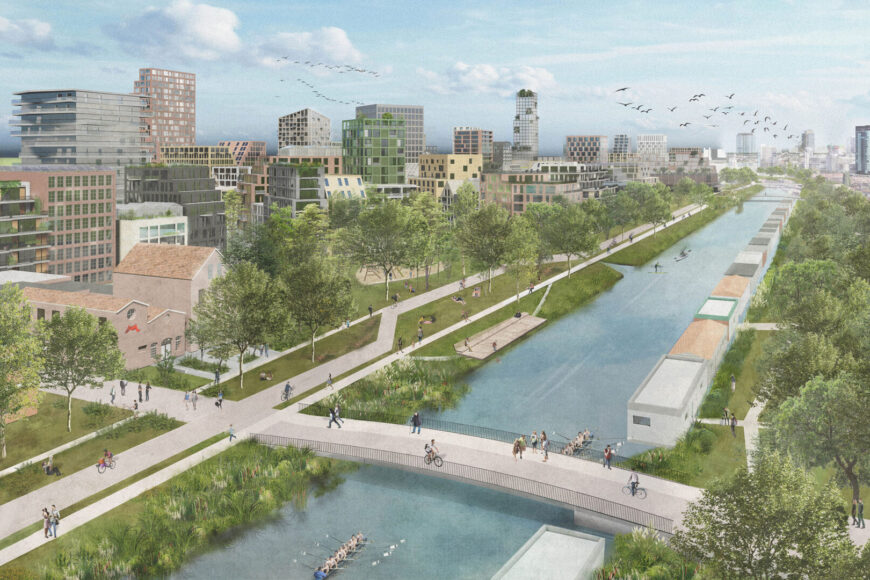
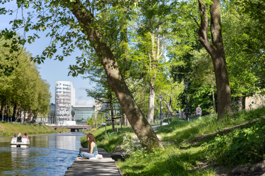
This need is met by the new waterfront park. Over a length of 1.3 km, this park, running along the Trekvliet, will form a green connection between the Spui and the country estates zone. The green will reach up to the buildings, contributing to the new quality of living. The Municipality of The Hague envisions the Binckhorst waterfront park as an addition of international allure to the city. The park embraces its industrial and raw heritage while incorporating active programming and climate-robust features, giving it a distinctive urban character.
5 Zones
The park itself consists of a series of 5 zones with their own character and identity. Binckhorst waterfront park, located on the north side, connects to the city centre and will be a large-scale natural counterpart to the city’s densification. The extensive greening will go hand in hand with a reappraisal of the historical industrial heritage on the site, so that the area retains its industrial character.
The adjoining areas of Laakmolen and Kasteeltuin will have a more romantic and formal character, respectively. The Fokkerhaven and Zuidkade, on the other hand, will have a more active and quieter character in succession.
Well embedded
For all domains, the stony character will make way for greenery, with a focus on pedestrians and cyclists. The Waterfront Park connects all urban districts adjacent to the Trekvliet Canal and provides a new, high-quality slow traffic connection from the estate’s zone to the Spui. In short, a new park that is aimed at a healthy living environment for all residents. The Binckhorst waterfront park embodies The Hague’s vision for urban development, harmoniously blending industrial heritage with contemporary living and creating a vibrant, sustainable, and inviting urban space for residents and visitors alike.


