
In Utrecht, an attractive, lively and green urban district will rise along the Merwedekanaal in the coming years. ‘The New Defence” will be the first quarter to be realised, showcasing and promoting the concept of ‘healthy living’ in a dense urban setting. Thanks to an innovative sustainable mobility concept, this new residential area will be largely car-free, allowing space for people and nature.
The refurbishment of Burgemeester van Nispen park is the culmination of the renewal of Hillegom’s centre. In the last decades, the village has developed into an attractive place to stay due to its location and living environment. To further increase this attractiveness for the future, extra attention has been paid to the green public spaces, resulting in Burgemeester van Nispen park and earlier the Hoftuin, each one adding a specific character and quality to this area of the city centre.
Set against the backdrop of the forthcoming Binckhorst park, the Grace takes its place within The Hague’s Central Innovation District with a metropolitan flair. Over 1400 residences are hosted within two soaring towers, one of which is poised to become the city’s tallest. The sheer scale of the development necessitates a seamless integration with its surroundings, maintaining a human touch throughout. To realise this vision, the outdoor spaces are thoughtfully conceived to harmonise with Binckhorst Park, forging a tranquil connection amid a tapestry of rooftop gardens.
Located in the southwest of France, the old city of Dax, like numerous small historical cities, fell victim to the pressure created by the overwhelming presence of cars and traffic it was never designed for. This resulted in a fragmented and damaged identity, and a poor quality of stay for its inhabitants and visitors. Our design reaffirmed the area around the Fontaine Chaude water source as an origin, this time to revitalise the city.
The Shenshan Coastal resilience framework plan, ‘Nature as leverage’, is a nature-based design program, seamlessly blending mountain, sea, and land development across a project area of 19 square kilometres. It is the outcome of a collaboration with MLA+, combining forces to pay homage to the rich Chinese historical water strategy, while interweaving it with the Dutch approach, resulting in a unique vision for coastal landscapes. The plan was declared winner of the competitive tender in 2019, and has since been adopted as foundation for further development initiatives.
Right beside Bunnik railway station, the former De Twaalf Apostelen office area is set to become a lively, inclusive, and green neighbourhood with 1,000–1,350 homes, workplaces, and facilities. What is now an underused paved site will soon transform into a place for living, meeting, and moving sustainably. Its immediate proximity to the station makes sustainable mobility a key principle in the development of the residential quarter. The surrounding beautiful landscapes of the Kromme Rijn, the countryside estates and the New Dutch Waterline further enhance the attractiveness of the area.
Utrecht’s inner city is characterised by historical authenticity however this had led to the inability to properly adapt to mobility and climate-related developments. Due to the long history of Utrecht’s city centre, most of its open space has been claimed and paved over time. It is precisely these qualities that make it difficult to design the city, like many other large historic city centres, to be climate-adaptive.
With one of the longest histories of any city in the world, Athens has faced numerous moments of reinvention and rebalancing. However, the last few decades of explosive growth have led to infrastructural problems and a socio-cultural imbalance, resulting in a decline of the city centre. The economic challenges have affected the quality of life and the environmental conditions, leaving Athens in need of revitalisation.
The town of Huizen is located in a prominent area on the Gooimeer. With a long coastline and Het Gooi region as the hinterland, there was a lot of untapped potential to strengthen the relationship with the water. For that reason, the municipality asked us to create an integral vision for the entire length of its coastline. Following the approval of the vision, the first implementation followed. The Zomerkade coast was transformed into a surprising urban beach that is now finally connected to the urban environment.
One integrated vision
In the past decades, many separate plans have been made for the coastal zone of Huizen, but they all lacked a coherent framework to link them together. As a result, individual developments did not reach their full potential and the implementation of plans stagnated. To get out of this impasse, we were asked to shape an integral vision using a participatory design process.
Wishes and attention points were collected and discussed in an extensive participation process which led to several key components of the vision; strengthening the connection between the historical town and the harbour, strengthening the green character of the coastline in general and concentrating new amenities and attractions to a limited number of hotspots linked to existing amenities.
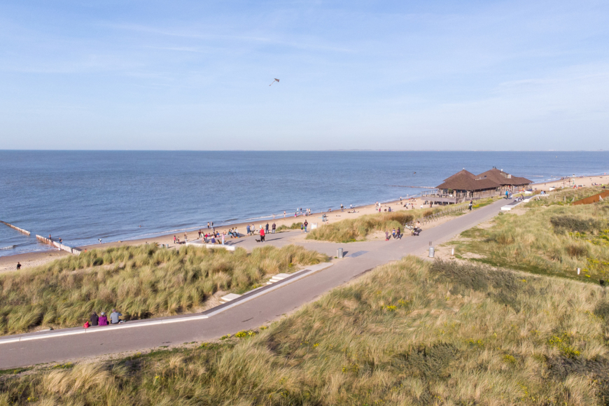
We transformed the coast of Zomerkade from a fragmented and inaccessible beach with a typical ’80s Dutch residential atmosphere, including carpark right on the beach, into a vibrant accessible and green waterfront. By removing the hard quay wall and unnecessary protrusions, the impressive crescent-shaped beach is brought to prominence. A clear and intuitive zoning defines areas for families, swimming and beach sports, all linked together by a new beach promenade and accessible from the quay by steps and slopes.
The design not only improves the beach itself, but also brings the atmosphere of the beach onto the quay, allowing for existing and new restaurants to best make use of their unique location and views.
Swimming at the coast
Due to the character of the lake floor, which gently slopes to a water depth of about a meter at most, actual swimming was never possible at the coast of Zomerkade. Our design includes the creation of a designated swimming area; a marked portion of the lake which has been deepened and protected against siltation. A long pier connects the swimming area to the beach promenade, where a new lifeguard station, shower facilities, a kiosk and food trucks are located. In addition, the new pier provides a mooring spot for SUPs, kayaks and other small vessels.
Green steps
The beach is made accessible through broad stairs and gentle ramps. The upper levels of the green steps host a meadow of colourful flowers, while the lower steped lawns provide seating and sunbathing spots. Along the bottom of the green stairs, the continuous beach promenade connects all recreational elements seamlessly.


