February 12, 2026 News


The École polytechnique district is a key piece of the plateau de Saclay’s transformation into a world-class scientific and technological cluster. Located 20 km southwest of Paris, the area has evolved from its historic role in the Versailles water system to an urban campus built around the École polytechnique grounds from the 1970s, fostering research, innovation and exchange, while acting as a powerful economic driver for the territory. Over the past decade, the district heart has come to life: landmark R&D and academic buildings have opened, major public spaces have been delivered and Paris-Saclay university now ranks 12th globally in the Academic Ranking of World Universities.


Our design builds upon the plateau’s exceptional landscapes, its agricultural fields, forested hills and wetlands, to enhance the quality of life and climate resilience of the district. We strengthen both visual and functional connections between the heart of the district and its surrounding natural areas. The built forms and public realm network are shaped to frame key views towards the fields, forests and hills. Pedestrian routes extend from the centre of the district into the plateau, offering direct access from the academic clusters and homes to outdoor spaces for sport, leisure and nature exploration and thus making the wider landscape an integral part of daily life.
We extend the plateau’s green and blue infrastructure into the heart of the district to weave the atmosphere and functions of the surrounding biotopes – wetlands, humid meadows, dry grasslands, and mixed forests -into private and public spaces. This approach delivers multiple benefits. Forested corridors, meadow clearings and wetlands penetrate the urban fabric, providing habitats and movement routes for birds, pollinators, amphibians and small mammals. Multi layered planting replicates the structure of local ecosystems and supports biodiversity. Rain gardens, bioswales and open-soil infiltration areas filter and slow stormwater whilst the extended tree canopy and green groundcover reduce urban heat islands, creating shaded, cooler microclimates in dense areas.


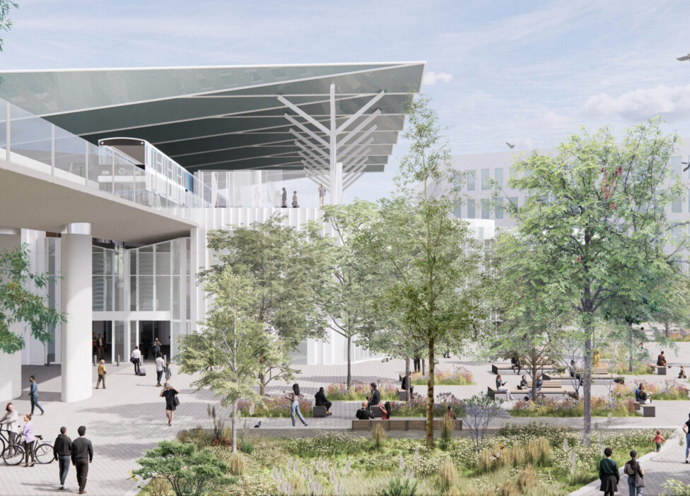
We use advanced climate modelling tools to refine our bioclimatic designs and ensure that public spaces achieve the best possible levels of comfort both in winter and summer. For one sector of the station, we applied climate modelling to inform the design of a new urban district dedicated to scientific research and innovation. Located between the neighbourhood’s urban core and its green northern edge, the project aims to create an open, permeable environment that supports interaction and exchange between research activities. Universal Thermal Climate Index (UTCI) simulations evaluated pedestrian thermal comfort by considering temperature, humidity, wind and solar radiation, while Computational Fluid Dynamics (CFD) modelling was used to analyse wind behaviour and the impact of new buildings on pedestrian-level comfort. The results directly informed the layout of buildings, public spaces and landscape elements, ensuring a high-quality, climate-responsive public realm across seasons.


We design public spaces as immersive landscapes that enhance the plateau’s qualities, creating active places for campus life, social interaction and connection with nature. At the district’s core, we extend the “chain of major spaces” into a vibrant public realm with lawns for informal gatherings, outdoor study areas, sports courts, family spaces, and adaptable squares for events, reflecting its evolving role as a place to live, study, and work.Our approach activates functional edges, transforming them into lively landscape fringes. The southern boulevard des Maréchaux becomes a calm urban avenue prioritizing pedestrians, safe active-mobility routes, and views of southern slopes and future bioswales. We also make sport a driver of urbanity and activation, with a northwest sports hub and a southern leisure edge integrating play, exercise, and landscape discovery. These spaces invite residents, students and visitors to experience the plateau daily and foster encounters.

“Our ambition is to make the plateau’s landscapes—its wetlands, forests, and open horizons—a lived reality within the innovation district. We design a resilient campus city where public life, ecological continuity and territorial anchoring come together to shape a new urban horizon.”
— Antoine Thevenet, Senior project leader, OKRA